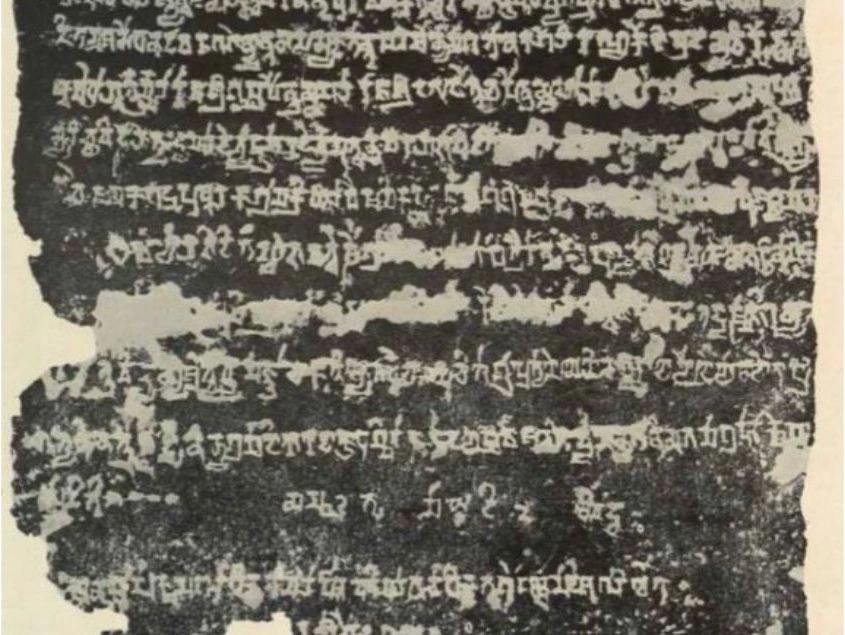
"The Ambassadors" (1533) by Holbein depicts two figures with scientific instruments, symbolizing Renaissance knowledge. A distorted skull at the bottom serves as a reminder of mortality.

Cliodynamics and Mathematical Models in History. Part 3

Practical visualisation

(Continued. See Part 1, Part 2)

Artzrouni and Komlos's spatial model provides a computational lens to study territorial evolution in Europe, prompting Peter Turchin to explore additional dynamics like Ibn Khaldun's "asabiyyah" for a more nuanced understanding of empire rise and fall.

To move on to the practical visualisation of the mathematical model of geopolitics in historical dynamics, let us consider the spatial model of territorial dynamics proposed by Artzrouni and Komlos in 1996. The researchers presented the map of Europe as a grid of square territories with linear dimensions of approximately 40 by 40 kilometres. At the initial time point (500 AD), a simulated space was created, filled with states of equal sizes (5 by 5 squares). That is, each initial "state" occupied an area of around 40,000 square kilometres on the map.
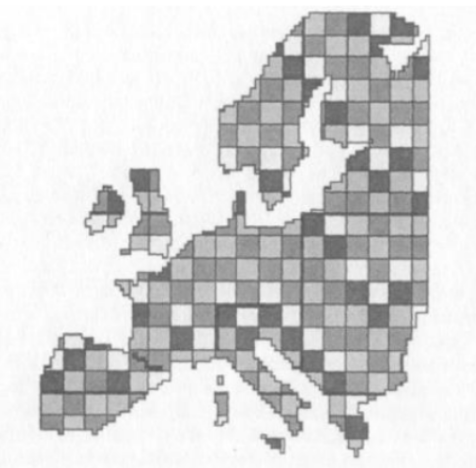
The map of Europe as a grid of square territories.

The Artzrouni and Komlos model assumed that each state's military power function had the following mathematical form:

The Artzrouni and Komlos' state military power function.

Where A and C are the area and the perimeter of the state, and α, β, γ are positive constants. In this model, the negative correlation with the "Rear Load" parameter outweighs the positive correlation from increased territory, causing the magnitude of the state's power to eventually decline to zero.

After the mathematical model ran all iterations from the year 500 to 1800, the following map was obtained as a result:
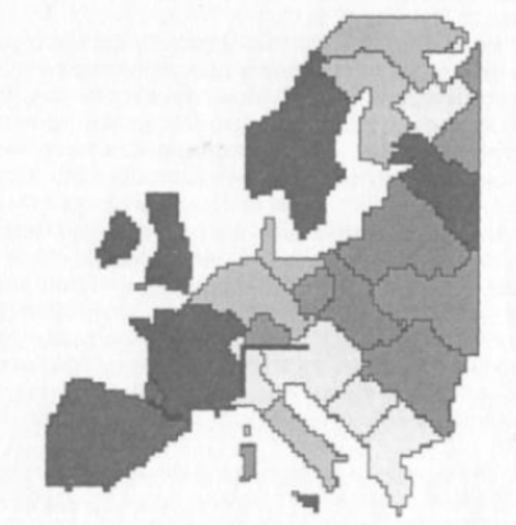
The resulting map of Europe after running the formula for the period from 500 to 1800 AD: the borders of Spain, France, the United Kingdom, Sweden, Greece, and Poland.

The map clearly illustrates the borders of such states as Spain, France, the United Kingdom, Sweden, Greece, and Poland (in our historical reality, as of 1800, not existing). In southern Italy, the features of the Kingdom of Naples begin to emerge. The German and Austrian states were found to be slightly "trimmed down," while there are a number of states on the map that did not exist at the period in real history. In fact, this model confirms that coastal countries are formed with a greater degree of historical certainty than inland countries, where the stochastic component has the greatest influence on the result. When simulating a dynamic process, one of the countries was chosen at random, and its strength was compared with the strength of all its neighbours. The countries with the greatest power disparity began a war, which the militarily powerful country won, with some probability indicated by the formula:

The formula predicting the winning side in the war of countries with the greatest power disparity.

Where Pi and Pj are the power of the warring countries, and K is an additional coefficient. Each iteration corresponded to a period of four months. In point of fact, the researchers were faced with the task of how to correctly select all the parameters for the equations in order to get a picture close to historical reality. The model's evident flaw is that the indicator of the country's peripherality takes precedence over the other elements of the geopolitical model and shows a visible influence of the state's favourable border position. Nevertheless, this model confirms the fact that large countries continue to expand until the “burden of empire” compels them to stabilise their size.

Returning to Collins' geopolitical theory, it follows that, in the end, every empire should always expect the process of annihilation, because the major mechanism of decline is the delay in reaction time to changes in other model variables. Research into the rise/fall of various states by the political scientist Rein Taagepera has revealed quite frequent cases of long periods of decline of large empires. This occurs as a result of the so-called "second-order dynamics," in which the correlation between the parameters of the models operates with some delay. Turchin concludes that models based solely on geopolitical mechanisms are incapable of predicting the exact dynamics of empire growth or collapse, and that other mechanisms for empire growth or collapse should be sought, one of which may be the very "asabiyyah" of Ibn Khaldun, or in other words, the collective solidarity of communities capable of self-organization and protection.

To be continued.

Don't miss out on the latest news!
Thank you! Your submission has been received!
Oops! Something went wrong while submitting the form.

People also read

a man studies history

Artificial Intelligence’s Unexpected Role in Uncovering Historical Silences

This article explores how AI can help address the problem of “historical silence,” where marginalized voices are excluded from narratives. Drawing on Michel-Rolph Trouillot’s framework, it highlights the potential of AI to expose biases and create counter-narratives, amplifying overlooked perspectives such as Indigenous resilience.
Miray Özmutlu
Miray Özmutlu
November 18, 2024
6
min read
Historical Research
Historical Events
ai and culture

AI for a Cultural History

This article explores the cultural history of artificial intelligence, from ancient myths to contemporary advancements. Learn how AlphaGo and GANs emphasize the connections between technology, philosophy, and culture. It advocates for a transcultural understanding of AI, addressing societal anxieties and aspirations in a narrative that humanizes technology.
Alexandre Gefen
Alexandre Gefen
November 5, 2024
10
min read
History
Cultural History
3D Technologies and AI

3D technologies and spatial AI applications in archaeology

This article explores the transformative impact of 3D technologies on archaeological research and documentation. It outlines three primary sensing tools used in modern archaeology: photogrammetry, Lidar scanning, and 3D cameras. Each method's strengths and applications are discussed, highlighting their roles in creating accurate digital representations of artifacts, sites, and landscapes. The integration of artificial intelligence in processing 3D models is examined, including element classification and the conversion of outdated maps into vector polygons.
noam bar
Noam Bar David
October 22, 2024
7
min read
Generative AI
Archaeology

Contribute to Historica's blog!

Learn guidelines, requirements, and join our history-loving community.

Become an author

FAQs

How can I contribute to or collaborate with the Historica project?
If you're interested in contributing to or collaborating with Historica, you can use the contact form on the Historica website to express your interest and detail how you would like to be involved. The Historica team will then be able to guide you through the process.
What role does Historica play in the promotion of culture?
Historica acts as a platform for promoting cultural objects and events by local communities. It presents these in great detail, from previously inaccessible perspectives, and in fresh contexts.
How does Historica support educational endeavors?
Historica serves as a powerful tool for research and education. It can be used in school curricula, scientific projects, educational software development, and the organization of educational events.
What benefits does Historica offer to local cultural entities and events?
Historica provides a global platform for local communities and cultural events to display their cultural artifacts and historical events. It offers detailed presentations from unique perspectives and in fresh contexts.
Can you give a brief overview of Historica?
Historica is an initiative that uses artificial intelligence to build a digital map of human history. It combines different data types to portray the progression of civilization from its inception to the present day.
What is the meaning of Historica's principles?
The principles of Historica represent its methodological, organizational, and technological foundations: Methodological principle of interdisciplinarity: This principle involves integrating knowledge from various fields to provide a comprehensive and scientifically grounded view of history. Organizational principle of decentralization: This principle encourages open collaboration from a global community, allowing everyone to contribute to the digital depiction of human history. Technological principle of reliance on AI: This principle focuses on extensively using AI to handle large data sets, reconcile different scientific domains, and continuously enrich the historical model.
Who are the intended users of Historica?
Historica is beneficial to a diverse range of users. In academia, it's valuable for educators, students, and policymakers. Culturally, it aids workers in museums, heritage conservation, tourism, and cultural event organization. For recreational purposes, it serves gamers, history enthusiasts, authors, and participants in historical reenactments.
How does Historica use artificial intelligence?
Historica uses AI to process and manage vast amounts of data from various scientific fields. This technology allows for the constant addition of new facts to the historical model and aids in resolving disagreements and contradictions in interpretation across different scientific fields.
Can anyone participate in the Historica project?
Yes, Historica encourages wide-ranging collaboration. Scholars, researchers, AI specialists, bloggers and all history enthusiasts are all welcome to contribute to the project.